How to reach the spots?
If you arrive via Rostock (e.g. A19 from Berlin or A20 from Hamburg) change to B105 at ‘Rostock Ost‘ and follow the 105 towards Ribnitz-Damgarten and further on to Stralsund.
The Southern Spots
-
 Saal
Saal
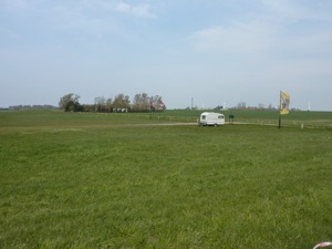
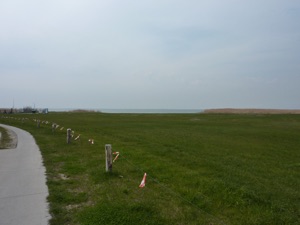
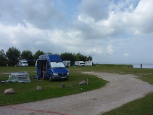
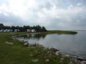
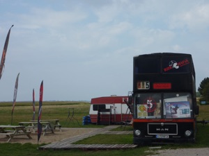
In Saal there are two spots suitable for windsurfing/kitesurfing. You can reach the first spot by exiting the L105 in Ribnitz Damgarten towards NVP2 (Schillstrasse - Barther Strasse - Saaler Chaussee) to Kueckenshagen and Saal (18317). In Saal stay on NVP2 (=Lange Strasse) and turn to the left towards ‘Gartenstrasse’ and follow this street towards ‘Am Bodden’. Keep right at the end and you will reach a wide green on the shore of the Bodden.
You may wish to navigate to spot A by GPS: Longitude: 54.3135 Altitude: 12.4808
There is a kitesurf school (kitemafia.de) with a black double decker bus and a large car park and rigging green. You can put up your tent or place your camper van next to the green (fee). During summer time there is also a small bar, cafe, wc and kite rental.
You will find flatwater conditions with choppy waters. The spot is mainly suitable for southwesterly or northerly winds (side onshore), however this spot will work with most wind directions.
If you drive a bit further along ‘Lange Strasse’ and choose the next street (=Damser Weg) (rather than Gartenstrasse) the street will lead you to another spot in Saal (spot B).
You may wish to navigate to spot B by GPS:
Longitude: 54.3203, Altitude: 12.4754
Although usually free of charge, they may charge you a fee for parking. You will find a rigging flat and easy entry via a small beach. The conditions are very similar to spot A, although northerly winds should be even better at this spot, which is roughly 400m north to spot A. -
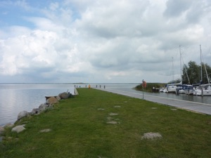
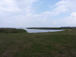
Michaelsdorf
Michaelsdorf is situated on a ‘peninsula like’ land extension just opposite of Born.
From Saal stay on the NVP2 to Neuendorf and further on to Neuendorf Heide. Turn to the left into ‘Waldstrasse‘ towards Neuendorf Heide just before you would enter the forest (or alternatively stay on NPV2 for a further kilometer and then turn left) and follow the street to Michaelsdorf. Choose the street ‘Am Roland‘ and drive to the end directly to the Bodden.
You may wish to navigate to the spot by GPS: Longitude: 54.3712 Altitude: 12.5703
Shallow water for all wind directions. For windsurfers (as usual for the Bodden): do not forget to bring your sea weed fin as there is a lot of grass around during the summer season. Please check, whether it is still allowed to surf here, as we found differing infos. It is definitely a very nice place to stay overnight on the camper parking lot. -
Pruchten
Small village, about 7km south of Zingst at the river Barth. The identically named city of Barth is called ‘vineta city’ as it is supposedly the place of the mystic Vineta, a town said to be flodded and vanished in ancient times (basically a North German version of Atlantis :-).
You can reach Pruchten either from Zingst on the L21 to the south or via the ‘Southern Spots‘ (see spots above and follow NVP2 from Saal via Neuendorf up to the end, turn left on L211 via Fuhlendorf and Bodstedt, then left to Pruchten on the L21. If your travelling on the B105 (Ribnitz-Damgarten to Stralsund) take the L23 in Loebnitz to Barth and then the L21 to the northwest (Pruchten/Zingst) before you reach Barth.
In Pruchten choose ‘Zeltplatzstrasse‘ to the East and you can either use the street to ‘Camping Naturpark‘ or the next street a bit further to the west to access the Bodden.
You may wish to navigate to Pruchten by GPS:
Longitude: 54.385631 Altitude: 12.659554
The access via the campsite road is not (always) open to the public, but it is said to be the better spot entry. So be prepared to walk a bit (300m).
The spot boasts flatwater conditions with best winds from W-E. It is also used by the kitesurf school from Zingst for tuition. Due to its shallowness, the spot is maybe not very suitable for windsurfers.
Some users at oase.com advise that about 300m to the west it is still shallow to your shoulder, but only a couple of meters (50-100) towards the north and east. Be also aware about some very shallow parts or items (flagged by buoys) and some hidden (unflagged) concrete parts and stones. For kiters be also aware of some piles hidden in the reed (Schilfguertel). -
Barth/Gloewitz
Another spot is located to the east of Barth.
Exit the city of Barth (to Barth follow more or less the instruction to Pruchten) on the eastern side on the road ‘Trebin’, which runs from the ‘Platz der Freiheit‘ south of the harbour and the hotel ‘Speicher Barth‘ parallel to the Bodden and leads to the road ‘Gloewitz‘ and the youth hostel Gloewitz (Jugendherberge).
The spot is directly next to the youth hostel and there is a small sandy beach next to the own harbour. The conditions are similar to the other Bodden spots: flatwater conditions and shallow waters. Due to its location in the middle of a narrow bay, which opens up to the north the wind might be shielded a bit from the west and east. Find out more on the homepage of the local windsurf school.
You may wish to navigate to Gloewitz by GPS:
Longitude: 54.3707 Altitude: 12.7615
Pictures: Saal spot A (I-IV)
Michaelsdorf (V-VII)